How to make a flight path animation for Instagram Reels (free)
By Aditya Sharma, founder of Miles · Updated · 6 min read
DEL DXB LHR) into Miles, pick the Reel 9:16 format and press Make the video. In about a minute you get a map video where the plane draws your route across a 3D globe, stop by stop.A flight path animation is the short clip you see at the start of so many travel Reels: a little plane leaves one city, curves across the map and lands in the next. It tells people where you went before you show a single photo. It used to mean an hour of keyframing in a video editor. Now it takes a minute in your phone’s browser.
What makes a good flight map video
The ones that hold attention on a Reel tend to share a few things:
- The route draws itself. Watching the line move is the hook. A static map with a dotted line is a photo, not a video.
- The destination is a surprise. If every city is on screen from the first frame, there is nothing left to wait for. Revealing each stop only as the plane heads there keeps people watching to the end.
- The path curves like a real flight. Planes fly great-circle routes, the shortest path over a round Earth, so on a map they arc rather than run straight. Delhi to London bends up over Central Asia. A straight line looks wrong to anyone who has watched the seat-back map.
- Labels people can read on a phone. Airport codes, city names and the distance of each leg, large enough to read without pausing.
How to make a flight path animation with Miles
- Open the editor at createmiles.com/create. It runs in your phone’s browser, so there is nothing to install. If you tapped a link inside Instagram or TikTok, open the page in Safari or Chrome instead: in-app browsers can’t save the finished file.
- Add your stops in order. Type airport codes such as
BOM SIN SYD, or city names. Miles knows over 200,000 cities and towns, so smaller places like Hampi or Kasol work too. You can also drop in a booking PDF, a screenshot of your itinerary or a CSV, and Miles reads the stops from it. - Leave each leg set to flight. Every flight gets its own plane, its own curved path and its own flight card.
- Pick a look and a format. Satellite shows a 3D globe with real imagery. Midnight, Paper and Mono are flat map looks, all free. For Instagram Reels, TikTok and YouTube Shorts choose Reel 9:16. Post 4:5 suits the feed, and there are Square 1:1 and Wide 16:9 too.
- Press Make the video. You sign in first (Google or an email link, both free); you can plan the route without an account. The video takes about a minute, and then it is ready to save to your phone.
Why the flight path curves
The shortest route between two airports on a round Earth is a great circle. Flattened onto a map, that route bends towards the nearest pole, which is why Delhi to London arcs up over Central Asia and why flights from India to New York head north rather than straight west. Miles draws each flight along its real great-circle path, so the arc in your Reel matches the one on the seat-back screen.
The bend is small on short hops like Delhi to Dubai and very visible on long ones like Delhi to New York (11,755 km). If you want the maths behind it, and why a plane usually flies a little further than the great-circle distance, see flight distance explained.
Connections: DEL DXB LHR is two flights
A trip with a connection is two flights, not one, so type every airport you passed through. DEL DXB LHR becomes Delhi to Dubai and Dubai to London, and the animation lands in Dubai before taking off again. That stop is part of the story: people can see you went through the Gulf rather than flying direct.
- Direct:
DEL LHRis one curved line of 6,731 km. - Via Dubai:
DEL DXB LHRis 2,182 km plus 5,498 km, 7,680 km in all, and the route visibly bends south to Dubai first.
Only add a connection you actually flew through. Leaving one out makes the route look direct when it wasn’t, and the total distance comes out short.
Flight cards: airport codes and distance
Each flight shows a card with the two airport codes and the great-circle distance for that leg, for example DEL to DXB, 2,182 km. On a phone screen this is what people read: the codes tell them where, the distance tells them how far. Airport codes work best for flights because they are short, and they make it obvious which airport you used in cities that have more than one, such as London or New York.
Long-haul legs on the 3D globe
For long flights, use the Satellite look. It shows a 3D globe with real imagery, and the globe turns to follow the plane, so a leg like Singapore to Sydney (6,293 km) or Delhi to New York reads as a real journey across the planet rather than a line on a flat map. The flat looks (Midnight, Paper, Mono) suit short regional hops, where a globe would barely move.
A trip of several long-haul legs in a row works well too: BOM SIN SYD curves south-east across the Bay of Bengal and then down over Australia, and each city appears only as the plane heads there.
Got your trip in an email? Let an AI assistant send it
If your flights are spread across a dozen booking emails, you don’t have to copy them out. If you use an AI assistant that can read your email, such as ChatGPT or Claude, ask it to find your flights and make a Miles video. The assistant sends Miles the route. Miles itself never sees your inbox.
What’s free and what isn’t
The free version makes a 720p video with up to 6 stops, which covers most flight trips with a connection or two. A one-off Trip Pass or a yearly Pro plan adds more stops, 1080p and 4K, and removes the watermark; see the pricing page.
Tips for posting it as a Reel
- Keep it 15 to 30 seconds. Three to six stops fits that well. A twelve-city route is better split into two Reels than rushed into one.
- Hook in the first 2 seconds. Start on the plane leaving, not on a title card. Movement is what stops the scroll.
- Add a text overlay with the trip name, such as “10 days, 4 countries” or “Delhi to Lisbon via Dubai”. People watching without sound still know what it is.
- Add a trending sound when you post. The video has no music on purpose, so it fits whatever audio is trending that week. Add it in Instagram, TikTok or your editing app. For hooks, audio and more formats, see these Instagram travel reel ideas.
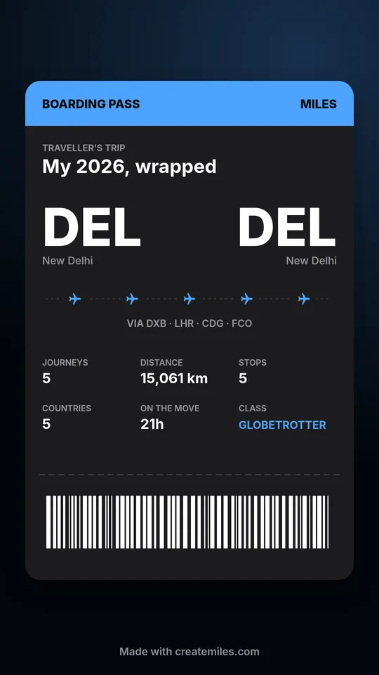
- Post the cards too. Miles also makes a boarding pass card, a “My trip, wrapped” card and a globe poster, in Story 9:16 or Post 4:5. Put them after the video in a carousel, or share them to your Story.
Want to share the video with family before you post it? Every video has a preview link that plays in any browser. Videos made on Miles’ servers can also be emailed to you as a link, which stays valid for 24 hours.
Other ways to make a plane map animation
You can also keyframe a plane along a map in a video editor, which gives full control but takes an hour or more and makes a believable great-circle curve fiddly. Template apps are quick for a single A to B flight but get awkward with connections, and screen recording a flight tracker only shows one flight at a time. For a side-by-side look at the dedicated tools, see the best travel map video apps.
Make a year of flights into one video
The same editor works for a whole year of trips. Add every flight from January to December as one route and you get a travel recap, with a wrapped card showing your kilometres, countries and how far around the world you went. Read more in what is a Travel Wrapped, or start one at createmiles.com/wrapped.